Site
Remediation News
July 2000 (Vol 12 No 1) - Article 03
Tidal Inlets—A Major Hurdle To Effectively Protecting Sensitive Coastal Resources
By: Robert J. Schrader
Department of Environmental Protection
300 Horizon Center, PO 407
Trenton, New Jersey 08625 USA
Miles O. Hayes and Todd M. Montello
Research Planning, Inc.
1121 Park Street
Columbia, South Carolina 29201 USA
Edwin A. Levine
National Oceanic and Atmospheric Administration
Battery Park Building, Room 301
New York, New York 10004-1466 USA
Abstract:
Along much of the coastline of the United States, the most abundant sensitive coastal resources, such as salt marsh and mangrove ecosystems, occur within estuaries located landward of tidal inlets. Therefore, a protection strategy that could prevent oil spilled on the open ocean from passing through the inlets during flood tides would effectively protect these resources. Because of wave conditions and strong currents (2-3 kts common), inlets present a most difficult protection scenario requiring excellent scientific understanding and operational skills.
As a result of the Anitra oil spill in 1996, the New Jersey Department of Environmental Protection (NJDEP) realized that the inlet protection strategies that had been proposed were not feasible. Based on previous experience for over two hundred tidal inlets in California and Florida, the NJDEP sponsored a project to devise protection strategies for the 13 inlets on the coast of New Jersey. The field team, which had backgrounds in geomorphology, environmental concerns, and response operations, devised the final strategies based on the following hierarchy of controls: (1) physical processes in the inlet; (2) protection priorities; and (3) probable effectiveness of response. The final strategies included boom positioning, probable oil movement, and other key elements. Special emphasis was placed on collection points, which were visited to determine access, habitat type, and boom deflection angles (and type). Inlets were classified according to degree of difficulty and expense of the response, and the most difficult ones were flagged for special concern. Strategies were devised and signed off on in the field, with significant input from local spill responders. A successful field test, which applied boom deflection and containment, was carried out in one of the typical inlets. Only through the combination of good scientific data, experience with years of on-scene operational know-how, field assessments, and refinement through field testing can effective strategies be developed to overcome one of the most difficult hurdles in successful oil spill protection. These strategies are designed as an educated starting point of operations to be modified according to the specific needs at the time of the incident.
Introduction
In the classic sense, tidal inlets are channels that divide barrier islands into segments. They are subject to reversing tidal currents, and are conduits for the volume of water that flows in and out of the bay/estuarine system landward of the inlet during a tidal cycle called the tidal prism. It is through these conduits that oil spilled on open ocean waters could reach the sensitive resources, such as salt marshes, that occur along the bay/estuarine shorelines. Coastal tidal inlets are therefore focal points for designing strategies to protect these vital resources from spilled oil.
|
|
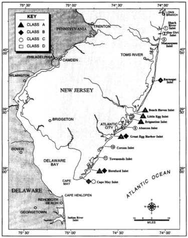
Based on Dr. Miles Hayes's experience in developing protection strategies for over 200 inlets in California and Florida, the NJDEP commissioned a project to develop potential protection strategies for each tidal inlet occurring along the Atlantic coast of the state, including a Geographic Information System (GIS) component. A total of 13 inlets, located on Figure 1, were surveyed during this project. The field study of the New Jersey inlets was carried out in August 1997.
The protection strategies that were proposed emphasized flood-tidal conditions, because the basic assumption was that the strategy be designed to deal with spilled oil coming to the inlet from the open ocean. These proposed potential strategies were based on the information at hand on waves and tidal currents. Where such data were missing, inferences based on the geomorphology were used.
Tidal Inlets—General
Tidal inlets on the sandy coastal plains of the eastern USA are usually formed by either of two mechanisms: (1) storm-generated scour channels (resulting inlets are usually shallow and prone to rapid migration); and (2) closure of estuarine entrances by growth of sand spits (resulting inlets usually deep and fixed in place).
As shown in Figure 2, a typical tidal inlet in a barrier island setting consists of a deep channel between the adjacent sand spits, called the inlet throat, and lobate-shaped sand bodies on either side of the inlet, called tidal deltas. The sand deposit on the landward side of the inlet, the flood-tidal delta, is typically composed of sheet-like lobes of sand with seaward-sloping ramps on their seaward sides covered by landward migrating waves of sand. The flood-tidal delta of Barnegat Inlet, New Jersey is illustrated by the oblique aerial photograph in Figure 3B. The sand deposit on the seaward side of the inlet, the ebb-tidal delta, is built seaward by ebb-tidal currents, but waves mold the outer margins into an arcuate shape and build landward migrating intertidal bars (swash bars) on the delta surface. The tidal flow on the ebb-tidal delta is horizontally segregated, with the main ebb channel, which usually projects perpendicular to shore off the inlet throat, being dominated by ebb-tidal currents. Shallower, flood-dominant channels (marginal flood channels) flank both sides of the ebb-tidal delta. The marginal flood channels are important in oil-spill response because the first waters to enter the inlet during the rising tide flow down these channels, even as residual ebb-tidal currents are flowing out the main ebb channel. This allows for a period of time (one hour or so) when any oil heading landward would be moving only down the marginal flood channels, during which time it could possibly be diverted to the adjacent sand beach, rather than allowing it to enter the inlet and impact the highly sensitive bay/estuary landward of it. The ebb-tidal delta of Corson Inlet is illustrated by the photograph in Figure 3A.
|
|

Tidal Inlets—Atlantic Coast of New Jersey
Of the 13 tidal inlets on the Atlantic coast of New Jersey, five are confined by a set of two jetties. These inlets are Shark River, Manasquan, Barnegat, Absecon, and Cape May. Three of the inlets, Great Egg Harbor, Townsends, and Hereford, have groins or other man-made shore protection structures (seawalls, riprap, etc.) along at least one shoreline of the inlet. Four of the inlets, Beach Haven, Little Egg, Brigantine, and Corson, are in a completely natural state, except for periodic dredging activities in some instances. These inlets that are still in their natural state can be expected to change rapidly, especially during storms. Sea Girt Inlet has been closed recently by natural processes, though it could open again during a major storm.
Meaningful tidal current information on the tidal inlets of New Jersey is relatively scarce. We found current data for only five of the inlets. Maximum tidal current velocities of between 2.5 and 3.7 knots are predicted for some of the inlets by the NOAA computer tide program Shio. However, the strongest sustained flow measured by the U.S. Army Corps of Engineers was 2.9 knots at Barnegat Inlet. Flood current velocities of 2.0-2.5 knots probably occur in most of the inlets. Higher velocities are to be expected during conditions of wind-assisted flows.
Inlet Protection Strategies Used
The field team that devised the protection strategies was diverse, with backgrounds in geomorphology, environmental concerns, and operational experience. In making a decision on a protection strategy, the following hierarchy of controls dictated the final strategy:
Physical processes of the inlet ![]() Protection priorities
Protection priorities ![]() Effectiveness of response
Effectiveness of response
|
|
||
| Figure 3. New Jersey tidal deltas.
Compare with diagram in Figure 2. Photographs taken at low tide on
26 August 1997. A. Ebb-tidal delta at Corson Inlet, looking southeast. B. Flood-tidal delta at Barnegat Inlet, looking south. |


If the waves were assumed to be too large or tidal currents too strong for booms to function in certain parts of the inlet, the strategy called for fall back to more protected sites. Most of the strategies include primary, secondary, and tertiary levels. Information from a number of sources dictated which parts of the estuarine system landward of the inlet required priority protection. Typically, most of the inlets contained sensitive salt marshes and tidal flats. The potential effectiveness of response was also given careful consideration. The probable effectiveness of a response would be controlled by such factors as access, particularly to collection points, types of equipment required, and logistics support required.
An example of how one of the protection strategies is presented graphically is given in Figure 4. In that example, Corson Inlet, it was assumed that it would be necessary to fall back inside the inlet for the first line of defense, except for deflection boom set up (under moderate wave conditions) on the outer beaches to deflect oil from the marginal flood channels to the beach, particularly during the early flood stage of the tidal cycle. Three sites were chosen as the primary collection points (labeled 1, 2, and 6 on Figure 4) for oil coming through the inlet throat. Site 1 is a sand beach area located directly landward of the inlet throat, and sites 2 and 6 are along the shoreline on the landward side of the two sand spits at the inlet entrance (Figure 4). The primary collection points have contingency backup deflection boom and collection points, should entrainment occur at the first line of defense. Protection boom is used to protect the marsh shorelines just seaward of Ocean Drive. The arrows indicate the probable path of surface oil during the flood tide. Some of the critical recommended anchor points for the boom are also shown.
A successful field test was carried out for one of the New Jersey inlets in the fall of 1997, which confirmed the general principles used to develop these strategies. With the successful test, the NJDEP Division of Science, Research and Technology along with the Bureau of Emergency Response proposed a full-scale drill on the Barnegat Inlet, a Class A inlet, in October 1998. The test was carried out and was unsuccessful due to the amounts of boom and the extreme current in the "throat" of the Inlet. The primary strategy for the Barnegat Inlet will be reevaluated and it is expected that the primary protection strategy will be just inside the inlet. Because of the department's dedication to the protection of the estuaries, the Shark River Inlet is scheduled to be tested on October 14, 1999.

Acknowledgments
The NJDEP, with Stan Delikat as contract monitor, is acknowledged for supporting this project. The protection strategies presented in this document were developed at collectively by a field team consisting of the authors, Michael F. Solecki of the U.S. Environmental Protection Agency; Cari Savarese and Philip G. Hamrick of the U.S. Coast Guard; Bill Andrews, Dave Jenkins, and Jeff Nourmant of the New Jersey Department of Fish, Game, and Wildlife; Karen Salomon of the U.S. Fish and Wildlife Service, and representatives of spill response contractors (Patrick McGovern and Joe Causton of Clean Venture/Cycle Chem; Robert C. Grimm and Captain Frank J. Simonson of National Response Corporation; John Lane, S&D; Frederick A. Viera of Marine Spill Response Corporation; Robert Springer of the Cape May County-New Jersey Public Works; and Francis McCall of Cape May County Emergency Management Communications Center). At Research Planning Inc., Dot Zaino and Joe Holmes are acknowledged for sharing the responsibility of producing the final product. Other local experts and relevant government representatives also participated in the development of the strategies for the inlets in their respective areas.
Biography
Rob Schrader has over 20 years of oil spill experience. Starting with the US Coast Guard for twelve years and presently a Response Specialist with the New Jersey Department of Environmental Protection, Bureau of Emergency Response. He has been On Scene Coordinator on numerous spills including the 1995 Jahray Spray and the 1996 Anitra oil Spill. He has authored articles for the International Oil Spill Conference and the NJDEP.
Dr. Miles O. Hayes is a coastal geomorphologist and clastics sedimentologist with over 35 years of experience in research on coastal processes and sedimentation. In 1997, he was awarded the Francis P. Shepard Marine Geology medal by the Society of Economic Paleontologists and Mineralogists. He has authored over 200 articles and reports on numerous topics, including oil pollution studies.
Edwin ("Ed") Levine presently serves as Scientific Support Coordinator (SSC), representing the National Oceanic and Atmospheric Administration (NOAA) Office of Response and Restoration (OR&R), in the coastal region from Connecticut through Delaware. In this capacity he serves as the science advisor to the Federal OnScene Coordinators during oil spills and chemical releases.
Over the past twelve years he has responded to dozens of incidents at the request of Federal and State officials, including eight weeks in Alaska for work on the Exxon Valdez oil spill. These responses were for products ranging from crude through refined oil to chemicals and even floatable debris in the New York Bight. The more noteworthy incidents in this area were the Exxon Bayway pipeline failure and spill, T/V Presidente Rivera and T/V World Prodigy, and Julie N tanker spills, T/B North Cape fire and spill, and the C/V Santa Clara I arsenic trioxide release.
As part of the contingency planning effort, Mr. Levine has helped review and comment on the Area Contingency Plans for the Coast Guard Captain of the Ports of Long Island Sound, New York and Philadelphia. He is also an advising member to the Regional Response Teams for Federal Regions II, III, and I.
In his previous position as Coordinator of Monitoring for the City of New York Department of Environmental Protection's, Bureau of Waste water Treatment, he supervised, managed and administered EPA compliance monitoring of the NY Bight ocean sludge disposal site (12mile site) and surrounding area, the annual NYC Harbor Water Quality Survey, and programmatic and nonprogrammatic sampling for the 14 City waste water treatment plants.
In 1981 Mr. Levine received his Master of Science in Marine Sciences from the University of Puerto Rico, Mayagüez, Puerto Rico. His thesis title was "Nutrient Cycling by the Red Mangrove (Rhizophora mangle L.) in Joyuda Lagoon, on the West Coast of Puerto Rico." In 1976 he received his Bachelor of Arts degree in Coastal Environmental Studies from Boston University, Boston, Massachusetts.
| Prev | Table of Contents | Next |
![]()
![]()
![]()
![]()
Please send your comments regarding the design or function of the NJDEP SRP Web pages to: srpweb@dep.state.nj.us
Last revision: 10 August 2000