Delaware • New Jersey • Pennsylvania
New York • United States of America

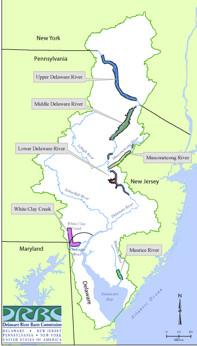 |
| Map showing stretches of National Wild and Scenic rivers in the DRB. Map by DRBC. View as pdf. |
The Creation of the National Wild and Scenic Rivers System
On October 2, 1968, the United States Congress approved legislation signed into law by President Lyndon Johnson that created the National Wild and Scenic Rivers System.
This law, known as the "Wild and Scenic Rivers Act," stated:
It is hereby declared to be the policy of the United States that certain selected rivers of the Nation which, with their immediate environments, possess outstandingly remarkable scenic, recreational, geologic, fish and wildlife, historic, cultural, or other similar values, shall be preserved in free-flowing condition, and that they and their immediate environments shall be protected for the benefit and enjoyment of present and future generations.
According to the National Park Service (NPS), when the Congress created the National Wild and Scenic Rivers System in 1968, it envisioned a cooperative system that would rely on the combined efforts of state, local and federal governments, along with individual citizens and non-governmental organizations.
The system was intended to be flexible enough to provide a means for communities to protect their rivers in a way that is sensitive to the needs and concerns of the people who live, work and recreate along the rivers.
According to the NPS, only 13,467 miles of 228 rivers in 41 states and the Commonwealth of Puerto Rico (less than one-half of one percent of the nation's rivers) are included in the National Wild and Scenic Rivers System.
Which Delaware River Basin Waterways have been Designated National Wild and Scenic Rivers?
As you can see on the map, there are six designated NWS rivers in the Delaware River Basin, including 3/4 of the non-tidal Delaware River, one tributary and sections of several other tributaries.
Designated: Upper Delaware River
In November 1978, Congress and President Jimmy Carter added 73 miles of the Delaware River to the National Wild & Scenic Rivers System.
The included section is from the confluence of the river's East and West branches at Hancock, N.Y. downstream to Millrift, Pa. All but 30 acres along these 73 miles is non-federal and most is privately owned.
Designated: Middle Delaware River
Also in November 1978, Congress and President Jimmy Carter added 40 miles of the Delaware River from just south of Port Jervis, N.Y. downstream to the Delaware Water Gap near Stroudsburg, Pa.
Nearly 70,000 acres along this 40-mile middle river corridor are part of the Delaware Water Gap National Recreation Area and owned by the federal government.
Combined, these the upper and middle river corridors take in approximately 145,000 acres.
- 1978 Law Adding the Upper and Middle Delaware Segments (P.L. 95-625; pdf)
Designated: Lower Delaware River
In an October 18, 2000, letter to U.S. Rep. Rush Holt, President Bill Clinton wrote:
"As you know, the future of the Delaware River, the longest free-flowing river in the eastern United States, is vital to the economy of the regions surrounding this important waterway. Wild and Scenic River designation will encourage natural and historic resource preservation and protect precious open space. By allowing local municipalities to sustain and protect the Delaware River as one of our nation's national treasures, this law will help to ensure the vitality of these communities and the quality of life of their citizens."
Weeks later, in November 2000, Congress approved a bill, which was signed into law by President Clinton, adding a section of the lower Delaware River to the national system.
- Lower Delaware Wild and Scenic Rivers Act (P.L. 106-418; pdf)
The Lower Delaware National Wild and Scenic River includes a 38.9-mile section of the main stem Delaware (and about 28 miles of selected tributaries, the Tinicum, Tohickon and Paunacussing creeks) linking the Delaware Water Gap and Washington Crossing, Pa., just upstream of Trenton, N.J.
The Lower Delaware section is managed as a Partnership Wild and Scenic River. Oversight is through a partnership of adjacent communities, state governments and the National Park Service.
The Lower Delaware celebrated its 15th Annniversary as a National Wild and Scenic River in 2015.
Designated: White Clay Creek Watershed
In October 2000, Congress and President Clinton added approximately 190 miles of segments and tributaries of the White Clay Creek to the national system.
- White Clay Creek Wild and Scenic Rivers System Act (P.L. 106-357; pdf)
This includes virtually the entire watershed, a first time occurrence in the national system.
The creek flows from southeastern Pennsylvania to northwestern Delaware and eventually joins the Christina River, a Delaware tributary to the Delaware River.
The White Clay is the first wild and scenic river designation in the state of Delaware.
The White Clay Wild and Scenic River is managed as a Partnership Wild and Scenic River. Oversight is through a partnership of adjacent communities, state governments and the National Park Service.
On December 19, 2014, President Barack Obama signed into law a bill that added approximately nine miles of the White Clay Creek and its tributaries to the existing Wild and Scenic Rivers designation for the waterway.
- White Clay Creek Wild and Scenic River Expansion Act (P.L. 113-291, Section 3073; pdf)
Passage of this bill means that the entire White Clay Creek Watershed is now included in the national system, making it the first National Wild and Scenic River protected in its entirety.
Designated: Maurice River
In December 1993, Congress and President Clinton added a segment of the Maurice River and several of its tributaries (including Menantico and Muskee creeks and the Manumuskin River), totaling 35.4 miles, to the national system.
- 1993 Law Adding Portions of the Maurice River and Tributaries (P.L. 103-162; pdf)
The Maurice River, located in New Jersey, is a Delaware Bay tributary.
The Maurice Wild and Scenic River is managed as a Partnership Wild and Scenic River. Oversight is through a partnership of adjacent communities, state governments and the National Park Service.
Designated: Musconetcong River
In December 2006, Congress and President George W. Bush added 24.2 miles of the Musconetcong River to the national system.
- Musconetcong Wild and Scenic Rivers Act (P.L. 109-452; pdf)
The Musconetcong is a non-tidal Delaware River tribuary located in New Jersey.
In June 2022, an additional 4.3-mile segment from Hughesville Mill to the confluence with the Delaware River was added to the national system.
The Musconetcong Wild and Scenic River is managed as a Partnership Wild and Scenic River. Oversight is through a partnership of adjacent communities, state governments and the National Park Service.
Related Resources