DEP PROMOTES CAMPAIGN ASKING TWO RIVERS AREA RESIDENTS TO HELP IDENTIFY PROPERTIES AS PART OF FLOOD RESILIENCY PLANNING
(17/P77) TRENTON –The Department of Environmental Protection and officials in the Two Rivers region of northeastern Monmouth County are encouraging the public to identify buildings and other facilities in their communities that should be part of focused flood-resiliency planning efforts.
 The Two Rivers, One Future campaign provides a unique opportunity for the public to use an online mapping website and social media to have a role in determining future flood-protection strategies for their communities. The DEP will evaluate the project with plans to expand it to other parts of the state.
“This project builds on our ongoing resiliency efforts and is intended to help the public better understanding flood risks while engaging them in the effort to protect their communities,” said Ginger Kopkash, DEP’s Assistant Commissioner for Land Use. “The DEP and its partners will be able to use information from this effort to develop strategies focused on protecting these important places.”
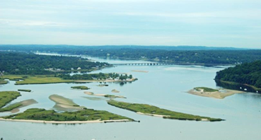
Located in northeastern Monmouth County around the Navesink and Shrewsbury rivers – short and wide estuary-like waterways – the Two Rivers region encompasses 15 municipalities, an area that is vulnerable to coastal flooding.
As part of the campaign, the community is asked to identify places such as public buildings, police and fire stations, municipal buildings, hospitals or urgent care centers, schools, important businesses, and popular gathering spots. The DEP will be conducting extensive outreach in Two Rivers communities this month to promote the campaign.
There are three ways the public can report locations:
- Go to www.TwoRiversOneFuture.nj.gov to drop pins at favorite locations, then describe in the comment field why the place is important.
- Tweet photos, websites, names or locations of the places that matter most, along with a reason why, and use the hashtags #MapWhatMatters and #TwoRiversOneFuture. The same hashtags may also be used on Instagram.
- Visit the Two Rivers, One Future #MapWhatMatters booth at a number of public festivals, markets and locations throughout the Two Rivers region this month. A schedule of events is available at www.nj.gov/dep/oclup/njframes-engage.html
The Two Rivers, One Future campaign is the latest component of the three-year New Jersey Fostering Regional Adaption through Municipal Economic Scenarios (NJ FRAMES) Project, which will use resiliency planning to help the Two Rivers Council of Mayors region prepare for and respond to coastal hazards and flooding risks.
The Two Rivers Council of Mayors works to address common issues in their communities. NJ FRAMES builds upon the cooperation of the communities in the region. The DEP has also been performing extensive mapping to identify areas vulnerable to flooding under various storm scenarios.
“While we have collected plenty of great data on at-risk areas in these communities, this effort will help ensure we are focusing our efforts on the right places, and those that matter most to residents,” said Assistant Commissioner Kopkash. “Strategies that could be implemented include green infrastructure, living shorelines and hardening of critical infrastructure that would better protect these places and their surrounding neighborhoods.”
The 15 communities in the Two Rivers region include Eatontown, Fair Haven, Highlands, Little Silver, Long Branch, Middletown, Monmouth Beach, Ocean Township, Oceanport, Red Bank, Rumson, Sea Bright, Shrewsbury Borough, Tinton Falls and West Long Branch.
NJ FRAMES partners DEP’s Coastal Management Program with the Jacques Cousteau National Estuarine Research Reserve, the Louis Berger Group, the Rutgers Climate Institute and the Borough of Oceanport, which represents the Two Rivers Council of Mayors. The project is funded by the National Oceanic and Atmospheric Administration (NOAA).
Project partners help the Two Rivers Council understand the range of costs and benefits of resiliency planning decisions by using a scenario-based approach for its communities. By using a vigorous public stakeholder process that involves the visions of the involved communities, the NJ FRAMES project is expected to develop a plan identifying a variety of measures to enhance flooding resiliency in the region.
NJ FRAMES is one of several resilience planning grants and projects funded by NOAA. To learn more about the project, visit: www.nj.gov/dep/oclup/njframes.html
Learn more about the DEP’s Coastal Management Program at www.nj.gov/dep/cmp and follow @NJCoastalManagement on Instagram.
DEP PHOTO/Navesink River
###