| No. |
Caption |
Image |
1. |
Entrance to Feeder above Raven Rock, seen from Pennsylvania side.
Date: 4/1935
Location: 27.2.5.5.8
Negative No.: 73-1 |
|
2. |
Raven
Rock Lock wall and lower gate.
Date: 4/1935
Location: 27.2.5.9.3.
Negative No.: 73-3 |
|
| 3. |
Raven
Rock Lock - part of wall.
Date: 4/1935
Location: 27.2.5.9.3.
Negative No.: 73-4
|
|
| 4. |
Repairs
to Feeder bank below Raven Rock. East end of Tract 36.
Date: 4/1935
Location: 27.2.6.8.6.
Negative No.: 73-5 |
|
| 5. |
Overflow
in Feeder bank at Hoffman's gate below Raven Rock.
Date: 4/1935
Location: 27.2.6.8.6.
Negative No.: 73-6 |
|
| 6. |
Bridge
and lock at Prallsville.
Date: 4/1935
Location: 27.3.4.8.1.
Negative No.: 73-7
|
|
| 7. |
Repairs
to wall of Feeder at Prallsville Lock. Damage caused by March 1936
washout. Thompson Company, Engineers - a contractor.
Date: 3/1936
Location: 27.3.4.8.1.
Negative No.: 91-9 |
|
| 8. |
Repairs
to washout at Prallsville.
Date: [3/1936]
Location: 27.3.4.8.1.
Negative No.: 91-10 |
|
| 9. |
Ruins
of lower gate of the Prallsville Lock after the March flood, 1936,
with debris left in the Feeder.
Date: [3/1936]
Location: 27.3.4.8.1.
Negative No.: 93-7 |
|
| 10. |
Repairs
to canal bank, Prallsville, due to uprooted tree. Rebuilding the
rip-rap along outer wall of Feeder embankment below the Prallsville
Lock.
Date: 10/1936
Location: --
Negative No.: 93-12 |
|
| 11. |
Damage
to Feeder bank by uprooted trees, a short distance below the Prallsville
Lock. Repaired by rebuilding rip-rap, as shown by 93-12 which represents
an adjacent area.
Date: [1936]
Location: 27.3.4.8.1.
Negative No.: 93-13 |
|
| 12. |
Canal
below the Prallsville Lock. Shows false work in lock for new cement
dam (at left). At right - exit of the water discharge conduits
on east side of lock. Discharge is controlled by gates at the upper
end of these conduits. 2 large 36' pipes will extend through the
dam as additional waste weirs for heavy floods.
Date: [1936]
Location: 27.3.4.8.1.
Negative No.: 93-15 |
|
| 13. |
Side
of Prallsville Lock - stone masonry on timber cribs.
Date: --
Location: 27.3.4.8.1.
Negative No.: 93-16 |
|
| 14. |
Building
the concrete dam at Prallsville - top of temporary cofferdam, and
side of lock wall.
Date: --
Location: 27.3.4.8.1.
Negative No.: 93-23 |
|
| 15. |
Prallsville
Lock Dam - concrete mixer.
Date: 10/1936
Location: 27.3.4.8.1.
Negative No.: 93-24 |
|
| 16. |
Prallsville
- Charles Wilson passing wet concrete from cement mixer.
Date: --
Location: 27.3.4.8.1.
Negative No.: 93-25 |
|
| 17. |
Re-enforcing
rods - Prallsville Lock Dam.
Date: 10/1936
Location: 27.3.4.8.1.
Negative No.: 93-26 |
|
| 18. |
Prallsville
Lock Dam - placing re-enforcing rods
Date: [1936]
Location: 27.3.4.8.1.
Negative No.: 93-28 |
|
| 19. |
Prallsville
- pipes in bottom of dam. Shows drain pipes through the base of
the dam before pouring the concrete. Pipes 36- or 40-inch diameter.
Date: [1936]
Location: 27.3.4.8.1.
Negative No.: 93-29 |
|
| 20. |
Pipes
in the bottom of the Prallsville Dam.
Date: --
Location: 27.3.4.8.1.
Negative No.: 93-30 |
|
| 21. |
Bottom
of Prallsville Lock Dam - placing the southern end of one of the
waste pipes. The other pipe is shown in upper lefthand corner of
cofferdam timbers (extend diagonally across the picture).
Date: 11/1936
Location: 27.3.4.8.1.
Negative No.: 93-32 |
|
| 22. |
Prallsville
- the cement mixer on a strike. Foreman Wilson bends over to see.
Date: 10/1936
Location: 27.3.4.8.1.
Negative No.: 93-33 |
|
| 23. |
Prallsville
- cleaning the carborator. Sometimes the cement mixer "struck," and
a council of war was held. "Dr." Charles Wilson to the
rescue.
Date: --
Location: 27.3.4.8.1.
Negative No.: 93-34 |
|
| 24. |
Foundations
of the concrete dam and lock at Prallsville - placing concrete,
one of the drain pipes [2 copies].
Date: - -
Location: --
Negative No.: 93-36 |
|
| 25. |
Barber's
farm bridge, north of Lambertville.
Date: 4/1935
Location: 27.3.8.5.7.
Negative No.: 73-8 |
|
| 26. |
Lambertville - Ent property.
Date: 4/1935]
Location: 27.13.2.2.3.
Negative No.: 73-9 |
|
| 27. |
Farm
Bridge No. 50 on Feeder, above the Workhouse.
Date: 4/1935
Location: 27.13.3.7.8.
Negative No.: 73-10 |
|
| 28. |
Junction
of the Main Canal and Feeder in Trenton [also shows Belvidere Delaware
Railroad].
Date:--
Location: 28.21.1.1.8.
Negative No.: 88- |
|
| 29. |
Junction
of the Main Canal and Feeder in Trenton.
Date: 8/1936
Location: 28.21.1.1.8.
Negative No.: 88-18 |
|
| 30. |
Lock
in Trenton.
Date: --
Location: --
Negative No.: 92-30 |
|
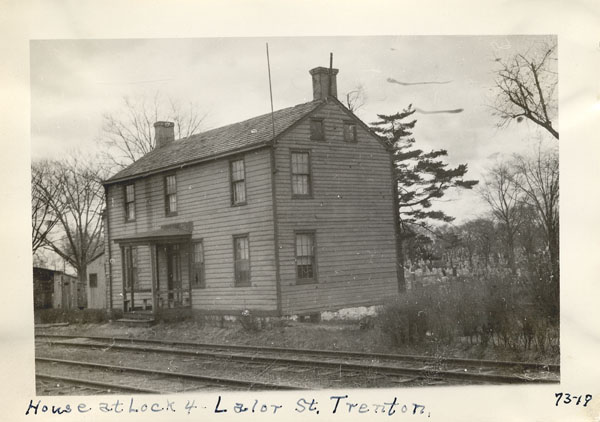
| 31. |
House
at South Broad Street, Lock No. 5, Trenton.
Date: 4/1935
Location: 28.21.4.4.3.
Negative No.: 73-20 |
|
| 32. |
House
at Lock No. 4, Lalor St., Trenton.
Date: 4/1935
Location: 28.21.7.2.1.
Negative No.: 73-19 |
|
| 33. |
House
at Lock No. 3, below Trenton.
Date: 4/1935
Location: 28.21.7.2.1.
Negative No.: 73-18 |
|
| 34. |
House
at Lock No. 2, below Trenton [2 copies].
Date: 4/1935
Location: 28.21.7.2.4.
Negative No.: 73-17 |
|
| 35. |
Abandoned
tug and barges, Bordentown.
Date: 4/1935
Location: 28.31.2.5.2.
Negative No.: 73-14 |
|
| 36. |
Houses
at Bordentown end - Crosswicks Creek in foreground.
Date: 4/1935
Location: 28.31.2.5.2.
Negative No.: 73-15 |
|
| 37. |
Lock
#9, Griggstown - west view [postcard to J. C. Person, Trenton].
Date: --
Location: --
Negative No.: -- |
|
| 38. |
House
at Griggstown, Bridge 19.
Date: 4/1935
Location: 28.2.2.8.6.
Negative No.: 73-21 |
|
| 39. |
Griggstown
culvert - upstream side.
Date: 4/1935
Location: 28.2.2.8.6.
Negative No.: 73-22 |
|
Consult the Reference services page
and/or the Guide to Reproduction and
Research Services, Policies and Fees for information on reproduction
of images included in this collection.
Created April
2004; Images added April 2008
|