Old Mine Road Ride Greenwood Lake Campgaw Caper Allamuchy Allegory Ride Washington Rock & Roll Tour Great Swamp Ride Three Easy Scenic River Rides Three Easy Scenic River Rides Round Valley Roundabout The North Shore and More Battle of Monmouth Ride D&R Canal Towpath Ride Last Covered Bridge Ride Burlington County Bikeways Double Trouble Pine Barrens River Ramble Cumberland Salem Revolution Bayshore Byways The Cape May Shoreline Ride East Coast Greenway High Point Cape May Bike Route Three Easy Scenic River Rides A Gloucester County Country Tour Jersey City to Hoboken Waterfront Tour The Columbia Trail Explore the Jersey Shore: Cape May to Somers Point Explore the Shore: Somers Point to Tuckerton Explore the Shore: Tuckerton to Brick Explore the Shore: Brick to Sandy Hook
Cumberland Salem Revolution

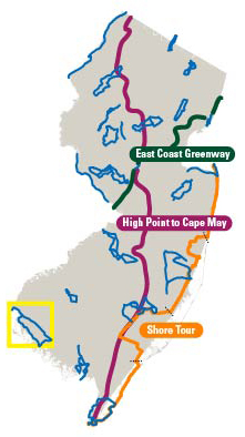
Travel through New Jersey’s Delaware Bay shore area, starting with an historic adventure through Salem County, the self-proclaimed garden spot of the garden state and continuing on into western Cumberland County. This area of New Jersey has the lowest population density in the state, and is on an almost uniformly flat coastal plain with a few easy climbs. The length of the ride may challenge some riders, and given the lack of windbreaks, windy conditions could increase the ride’s challenge level. However, there are opportunities to short circuit the tour along the way.

The route begins and ends at the parking lot entrance of Fort Mott State Park, an 1896 fortification built in anticipation of the Spanish-American war, and one of three forts located at this point along the Delaware River. The others are Fort Delaware, on Peapack Island in the Delaware River and Fort Dupont across the River in Delaware City, DE.

Fort Delaware was a Union fortress built to protect the ports of Wilmington and Philadelphia and served as a prison for Confederate prisoners of war. Fort Dupont was actively used as a military base from the Civil War through World War II. Try to leave enough time before or after your ride to visit these military compounds via the Three Forts Ferry operated by the Delaware River and Bay Authority (DRBA), which regularly updates visitor information and the ferries’ fees and schedules on their web site.

Leave the park and pass by Finn’s Point National Cemetery, which is the resting place for confederate soldiers who died while imprisoned at Fort Delaware. Then ride by Finn’s Point Rear Range Lighthouse, part of a system of range lighthouses used for navigation on the Delaware River.

Visit other historic sites en route such as:

Cumberland Salem Revolution photo
The Salem Oak
Located along West Broadway in Salem on the Friends (Quakers) Burial Ground, the tree is more than 80 feet high and estimated to be more than 500 years old. Under its branches, John Fenwick, an English Quaker who established Salem in 1675, is said to have signed a treaty with the Delaware Indians, who sold the land, but reserved their rights of trapping, fishing, and the privilege of cutting certain kinds of wood for the purpose of making baskets and canoes. The treaty was faithfully fulfilled until 1800 when the few remaining local Indians applied to the New Jersey Legislature to sell all their rights and privileges in the state. They merged with the Mohawks in New York State.

Historic Greenwich
Known for the Tea Burning at Greenwich on December 22, 1774, the town was the location of the Last Tea Party that followed similar protests in Boston, New York, and Annapolis. Visit the Greenwich tea party monument, which is dedicated to the memories of the tea burners, then ride down Teaburner Street.

Hancock House
Ride by the Hancock House in Hancock’s Bridge, Lower Alloways Creek Township. In 1734, William Hancock and his wife Sarah built the house. Their initials [WHS] and the construction date are in the distinctive zigzag brickwork on the house’s west gable end. British loyalist raiders massacred the patriots sleeping in the home during the American Revolution on March 21, 1778. Hancock House opened to the public on the 220th anniversary of the massacre.

File Formats
  • KML (12k)
    Use to view tour guide routes in a mapping application on a desktop computer, mobile device or GPS device.
  • Geospatial PDF (4.2m)
    Use to view your current location along the tour guide routes using a GPS enabled mobile device.
  • PDF (2.5m)
    Use to view or print the tour guide routes in a brochure format.

Instructions for using these files formats is available.