| NJ Home | | | Services A to Z | | | Departments/Agencies | | | FAQs |

|
||||||||||||
|
| ||||||||||||
|
|
|
|
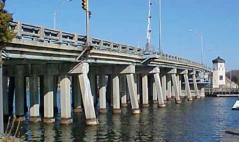
OverviewThe $52 million project to replace the Route 70 bridge over the Manasquan River in Brick Township, Ocean County and Borough of Brielle, Monmouth County began in early 2006. It will be completed by December 2010. Currently, the project is ahead of schedule. The work will be done in stages, some of which will require brief detours. Besides replacing the bridge, the work includes widening and reconstructing Route 70 from Herbertsville Road in Brick Township to the intersection with Riverview Drive in Brielle. The communities have been active participants in this project.
The public will be able to get information from variable message signs, radio traffic reports, real time traffic information, NJcommuter.com and other online and electronic outlets at schools and workplaces. In September 2004, the bridge was designated the "September 11 Memorial Bridge" in remembrance of the 170 people from Monmouth and Ocean counties who died in the terrorist attacks on September 11, 2001. Memorial architecture has been incorporated into the project.
This project is one component of a comprehensive infrastructure improvement of the Route 70 corridor from Jack Martin Boulevard to the Brielle Circle. Community Outreach The project also addresses the community's need for a well-balanced, aesthetically pleasing structure that fits into this unique river environment. Since being designated as the "September 11 Memorial Bridge", the project scope was enhanced to include architectural treatments to the piers and parapets, monuments, signage, plantings and a public access platform. Ongoing cooperation will continue to ensure timely responses to community issues that may arise during construction. Meetings will be posted. BackgroundConstructed in 1936, the original bridge is 625-feet long with a single leaf bascule span over the navigation channel. The 17 approach spans are supported on reinforced concrete pile bents. It has been necessary to retrofit the bridge with a sprinkler system to prevent the bridge from becoming stuck in the open position during the summer months. The existing bridge is structurally deficient and functionally obsolete with 11-foot travel lanes, a 50-foot navigation channel and 15-foot vertical underclearance. Bridge replacement alternatives including 40', 27' and 25' fixed and movable spans were investigated for the replacement. All alternatives considered the function of the local roadway network, alignment of the proposed roadway and constructability. A vessel height survey was performed using state-of-the-art reflectorless survey equipment, interviewing local marina owners and conducting public information sessions with the community stakeholders. Based on these extensive studies, the bridge height was set to provide a 25-foot vertical underclearance for marine traffic and the navigation channel opening was shifted and widened to 75 feet.
|
 |
Contact Us | Privacy Notice | Legal Statement | Accessibility Statement |  |
| department: home | about | NJ commuter | in the works | business | engineering | freight, air & water | capital | community | data | links | index | ||
| statewide: NJ Home | about NJ | business | government | state services A to Z | departments |
||
| Copyright ©
State of New Jersey, 2002-2020 Department of Transportation P.O. Box 600 Trenton, NJ 08625-0600 |
|
|
Last Updated: September 26, 2008 |
||