|
|
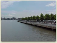
Hudson River Waterfront Walkway
 With
more than 1,100 people per square mile, New Jersey is the most densely populated state in the Union. Much of this population
resides in the northeast portion of the state where development pressures
are intense, especially along the waterfront. Fulfilling the duties
as required by the Public Trust Doctrine of preserving and protecting
public access to trust lands, waters, and resources in this urban
setting can be a significant challenge for the state’s planners and
lawmakers. The Hudson River Waterfront Walkway (Walkway), a waterfront
corridor spanning nine municipalities, balances the interests of economic
development along a thriving waterfront with the public's right to
access opportunities along tidal waters. With
more than 1,100 people per square mile, New Jersey is the most densely populated state in the Union. Much of this population
resides in the northeast portion of the state where development pressures
are intense, especially along the waterfront. Fulfilling the duties
as required by the Public Trust Doctrine of preserving and protecting
public access to trust lands, waters, and resources in this urban
setting can be a significant challenge for the state’s planners and
lawmakers. The Hudson River Waterfront Walkway (Walkway), a waterfront
corridor spanning nine municipalities, balances the interests of economic
development along a thriving waterfront with the public's right to
access opportunities along tidal waters.
The
concept for the Hudson River Waterfront Walkway first appeared in
"The Lower Hudson", a study completed in 1966 by the Regional
Plan Association. Twelve years after the publication of “The Lower
Hudson”, Governor Brendan Byrne established the Hudson River Waterfront
Study, Planning, and Development Commission. Their final report included
a recommendation for a continuous public
walkway extending along the Hudson River
In
1988, the Coastal Zone Management rules established specific criteria
for development along the Hudson River Waterfront Area including the
creation of the Hudson River Waterfront Walkway. When complete, this
Walkway will be an urban waterfront corridor connecting the George
Washington Bridge in Fort Lee with the Bayonne Bridge in Bayonne.
As the crow flies it will extend about 18.4 miles, but the total length
will exceed 40 miles. Nearly complete, the Walkway offers residents
and visitors spectacular views of the Statue of Liberty, the New York
City skyline, Ellis Island, and the Hudson River.
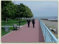 Historically,
public access to the waterfront in this urban area was precluded by
industrial use of the land. As existing land uses change, this "pathway
for the people" is reestablishing the public's right of access
to and full enjoyment of the tidally flowed and formerly flowed filled
waterways. The Walkway integrates historic neighborhoods with new
offices, housing and commercial development. People are drawn to the
waterfront and the open space, views, and community feel of the area,
and visitors to the Walkway engage in a variety of recreational activities
including walking, running, biking, sightseeing, and fishing. The
Walkway is a testament to the value of imaginative urban planning
that considers the public benefit at large. Historically,
public access to the waterfront in this urban area was precluded by
industrial use of the land. As existing land uses change, this "pathway
for the people" is reestablishing the public's right of access
to and full enjoyment of the tidally flowed and formerly flowed filled
waterways. The Walkway integrates historic neighborhoods with new
offices, housing and commercial development. People are drawn to the
waterfront and the open space, views, and community feel of the area,
and visitors to the Walkway engage in a variety of recreational activities
including walking, running, biking, sightseeing, and fishing. The
Walkway is a testament to the value of imaginative urban planning
that considers the public benefit at large.
Through public-private partnerships established among state and local government, commercial developers, and public interest groups, additional segments of the Walkway have been and will be constructed. Most recently, in October of 2014, North Bergen and Guttenberg opened the joint 1.5 acre Waterfront Park on River Road. The park was fully funded through the Hudson County Open Space Trust Fund and New Jersey's Green Acres Program, and is one of the few green open spaces in Guttenberg. Also on January 31, 2014 a new section of the walkway in Hoboken between Sinatra Park and Castle Point Park was opened. This includes a section completed by the Stevens Institute of Technology and a rebuilt section of the walkway around Sinatra Field. With the opening of this walkway, Hoboken now has a continuous waterfront multiuse path from the Jersey City border to their skate park at Castle Point. Previously, sections of the Walkway were completed in 2012, including Weehawken Cove connecting Weehawken and Hoboken, Steven’s Institute in Hoboken and the Moorings condominiums in Edgewater. With these completions it is now possible to walk or bike from Goldman Sachs in Jersey City to the northern end of North Bergen, over seven miles.
|