Delaware • New Jersey • Pennsylvania
New York • United States of America
- DRBC & PEMA: Hazard Mitigation Planning
- Projecting Extreme Precipitation in the Delaware River Basin
- Interstate Flood Mitigation Task Force
- Multi-Jurisdictional Flood Mitigation Plan For The Non-Tidal N.J. Section of the DRB
- Flood Insurance Claims in the Delaware River Basin
The DRBC is partnering with the Pennsylvania Emergency Management Agency (PEMA) to host a series of workshops for local officials in several Pennsylvania counties to help them advance hazard mitigation (e.g., flood loss reduction) projects for FEMA funding approval.
The workshops are geared for folks working in local government, planning, conservation, floodplain or emergency management or those who work with folks in those fields.
Purpose of Workshops
- Work with stakeholders in low-capacity communities to:
- Increase the capacity of local municipalities to apply for grants;
- Provide education and outreach on application process and timeline; and
- Advance Hazard Mitigation Plans to mitigation project development and actions.
- Increase the capacity of local municipalities to apply for grants;
Regional Focus
- In 2021 and 2022, the effort focused on the Upper Delaware and included the Pa. counties of Wayne, Pike, Monroe and parts of Lackawanna.
- In 2024, the effort has moved to the Middle Delaware, centering on the Pa. counties of Carbon, Northampton, Lehigh, Bucks and parts of Luzerne, and including a new focus on climate change and equity.
- Learn more about the PEMA Middle Delaware Flood Mitigation Assistance Workshops (Day 1: March 2024; Day 2: April 2024)
This project is being funded by the Federal Emergency Management Agency (FEMA) Building Resilient Infrastructure and Communities (BRIC) grant program.
The DRBC will continue to seek opportunities to partner with Basin state emergency management agencies to support flood mitigation efforts.
In March 2024, the DRBC released a new, interactive tool that allows users to obtain estimates of future changes in intensity, duration and frequency (IDF curves) of extreme rainfall in the Delaware River Basin, thereby informing stormwater management and infrastructure design and increasing climate resilience.
In September 2004, April 2005, and June 2006, three major floods caused devastation along the main stem Delaware River.
Recognizing that reducing flood loss is a responsibility shared by federal, interstate, state, and local governments throughout the basin, the governors of Delaware, New Jersey, New York, and Pennsylvania cosigned a September 2006 letter (pdf 400 KB) in which they wrote:
"Individually, the Basin states can move forward with policies and regulations to reduce and mitigate the impacts of flooding, but we believe that through coordinated effort on a regional basis, we can do more to reduce flood loss within the Basin than we could accomplish acting separately, on our own. The Delaware River Basin Commission is the obvious vehicle for developing flood loss reduction and flood mitigation plans that cannot be accomplished by any single state or local government but that require a holistic, watershed approach. As much as any time since the Commission was created in 1961, now seems an appropriate moment for coordinated action through the DRBC."
The September 2006 letter from the four governors directed DRBC staff to convene an interstate task force to develop a set of recommended measures for mitigating and alleviating flooding impacts along the Delaware and its tributaries. In July 2007, the Delaware River Basin Interstate Flood Mitigation Task Force forwarded to the four basin state governors its action agenda for a more proactive, sustainable, and systematic approach to flood damage reduction. The final report with 45 consensus recommendations addressed six management areas: flood warning, reservoir operations, floodplain regulation, floodplain mapping, structural and non-structural mitigation, and stormwater management.
July 2007 Task Force Final Report/Action Agenda
- Executive Summary (pdf 47 KB)
- Complete Final Report/Action Agenda (pdf 6.7 MB)
- Cover Letter From DRBC Executive Director to the Governors (pdf 68 KB)
- News Release
- Task Force Archives
The DRB Interstate Flood Mitigation Task Force met on December 15, 2009 at the Hunterdon County Complex in Flemington, N.J. to discuss implementation progress on several Task Force recommendations highlighted in its final report. Presentations were given on flood warning improvement recommendations, flood analysis model results, and floodplain management recommendations.
- Meeting Agenda (pdf 8 KB)
- Flood Warning Improvement Recommendations (pdf 1.3 MB)
- Flood Analysis Model
- Floodplain Management Recommendations - Presentation (pdf 545 KB) & Report Summary (pdf 70 KB)
- Floodplain Regulations Recommendations
One of the six priority management areas identified in the Interstate Flood Mitigation Task Force Report was structural and non-structural mitigation measures. Two of the nine specific recommendations in this management area included:
- Provide training for local officials to maximize use of available mitigation funding; and
- Evaluate and coordinate flood mitigation plans and strategies
Thanks to a grant awarded by FEMA in 2006, DRBC partnered with the N.J. Department of Environmental Protection and the state’s Office of Emergency Management to develop a multi-jurisdictional flood mitigation plan for 43 New Jersey municipalities located in Hunterdon, Mercer, Sussex and Warren counties in the DRB. This plan, which was approved by the Federal Emergency Management Agency (FEMA) in a letter dated November 7, 2008, contains over 160 locally developed mitigation actions that, if implemented, could reduce future flood loss.
The main purposes of this flood mitigation planning effort were to help participating communities become more disaster resistant by reducing the long-term risks from flooding and to enable them to become eligible to compete for FEMA funding aimed at flood mitigation. The plan is unique in that while it will meet the flood mitigation plan requirements of each municipality, it also will employ a watershed management approach to ensure that final mitigation actions address both local jurisdictional needs and regional, multi-jurisdictional needs.
November 2008 Final Plan
- Letter Announcing FEMA's Approval of Plan - November 7, 2008 (pdf 62 KB)
- Front Cover, Acknowledgements, Table of Contents, and Executive Summary (pdf 196 KB)
- Section 1 - Introduction (pdf 1.5 MB)
- Section 2 - Planning Process (pdf 414 KB)
- Section 3 - Flood Hazard Identification and Profiling (pdf 1.1 MB)
- Section 4 - Risk Assessment (pdf 320 KB)
- Section 5 - Basinwide Mitigation Strategy (pdf 140 KB)
- Section 6 - Flood Profile and Mitigation Action Plan by Jurisdiction
- Mercer County (pdf 639 KB)
- Hunterdon County (pdf 1 MB)
- Warren County (pdf 878 KB)
- Sussex County (pdf 348 KB)
- Mercer County (pdf 639 KB)
- Section 7 - Plan Adoption and Plan Maintenance Procedures (pdf 32 KB)
- Appendix A - Mitigation Plan Crosswalk (pdf 306 KB)
- Appendix B - Municipal Statements of Intent (pdf 5.5 MB)
- Appendix C - Forms Prepared for Municipalities (pdf 1.5 MB)
- Appendix D - County Floodplain Maps (pdf 2.7 MB)
- Appendix E - Sample Plan Resolution (pdf 10 KB)
- Appendix F - Resolutions of Plan Adoption (pdf 2.2 MB - May 6, 2010)
- Appendix G - Approval Letter (pdf 65 KB)
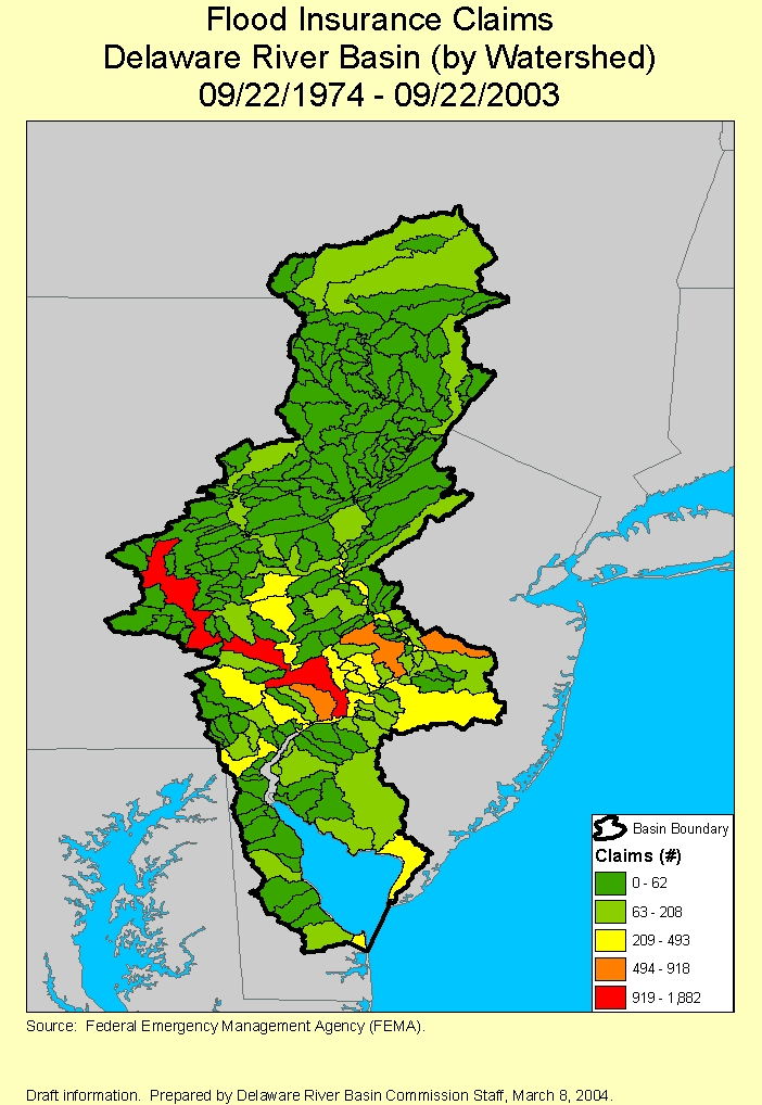
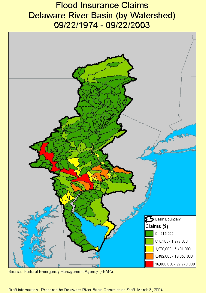
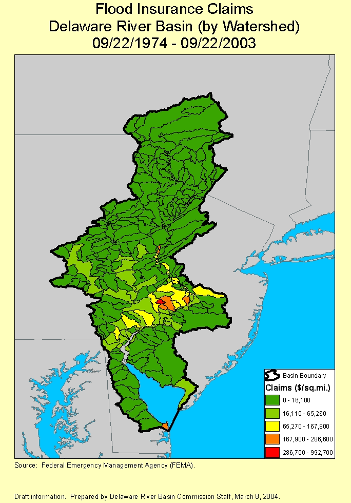
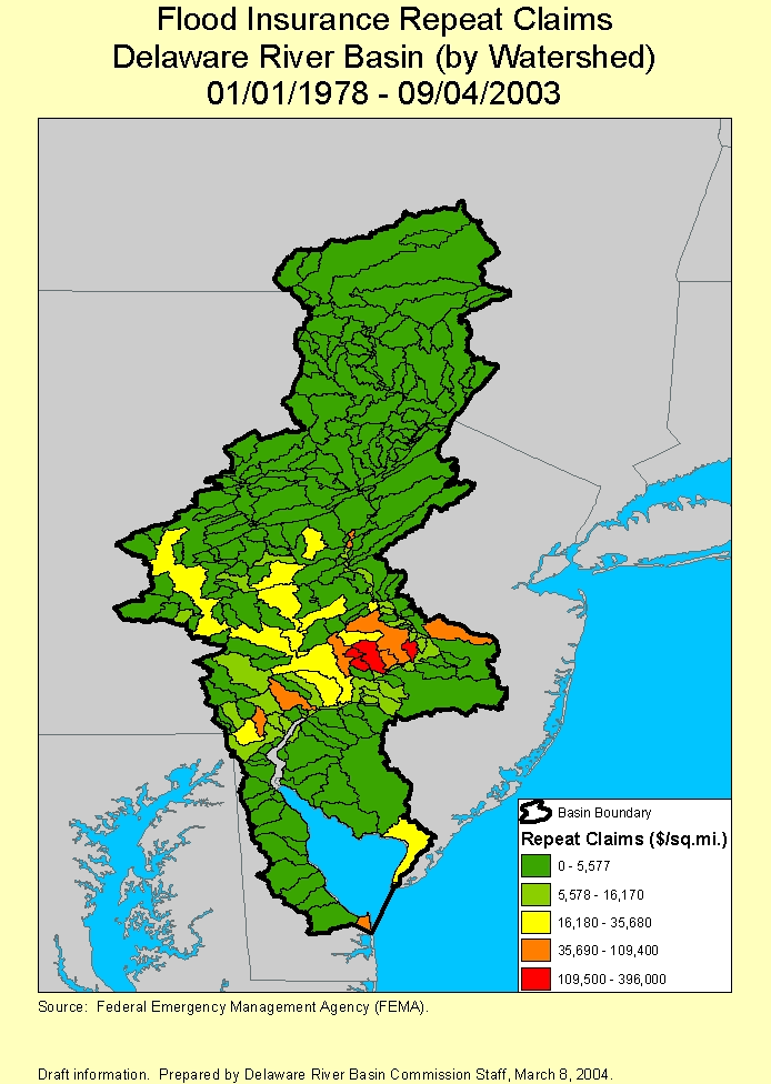
DRBC staff has performed analyses of flood insurance claims in the Delaware River Basin.
This is a comparative analysis of the National Flood Insurance Program (NFIP) closed claims in the Delaware River Basin for the September 2004 (Remnants of Tropical Storm Ivan), April 2005, and June 2006 flood events.
The analysis, prepared by DRBC staff in April 2007, includes GIS maps that graphically show the number of closed NFIP claims per municipality, a detailed listing of total claims and payouts per municipality, and a summary table showing the municipalities and counties with the largest numbers of NFIP claims per flood event.
Please note that this analysis does not represent uninsured flood damage. The source of the information is the Federal Emergency Management Agency (FEMA) and is subject to change.
- Comparative Analysis Table of Counties and Municipalities Most Affected by Each Flood (pdf 24 KB)
- Remnants of Ivan -- Dates of Loss Displayed: September 17, 2004 - September 20, 2004 (Data includes NFIP closed claims as of February 28, 2007.)
- April 2005 Flood Event -- Dates of Loss Displayed: April 2, 2005 - April 5, 2005 (Data includes NFIP closed claims as of February 28, 2007.)
- June 2006 Flood Event -- Dates of Loss Displayed: June 26, 2006 - June 30, 2006 (Data includes NFIP closed claims as of February 28, 2007.)
- View Entire Report (pdf 3.2 MB)
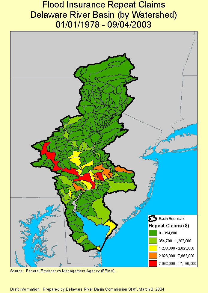
This is an analysis of FEMA-designated repetitive and severe repetitive loss properties in the Delaware River Basin.
The analysis, prepared by DRBC staff in April 2007, includes GIS maps that graphically show the number and dollar amount of repetitive loss properties and severe repetitive loss properties per municipality, as well as a detailed listing of the loss properties and a summary table showing the most affected municipalities and counties according to number and dollar amount of designated loss properties.
Please note that this analysis does not represent uninsured flood damage. FEMA is the source of the information, which is subject to change.
The analysis considered NFIP closed claims from January 1, 1978 through February 28, 2007. A property is considered a repetitive loss property by FEMA when there are two or more losses reported which were paid more than $1,000 for each loss; the two losses must be within 10 years of each other and be at least 10 days apart. A property is considered a severe repetitive loss property by FEMA either when there are at least four losses each exceeding $5,000 or when there are two or more losses where the building payments exceed the property value.
- Summary Table of Counties and Municipalities with Most FEMA-Designated Loss Properties (pdf 19 KB)
- Repetitive Loss Properties -- (Data includes NFIP closed claims as of February 28, 2007.)
- Map Depicting Number of Repetitive Loss Properties by Municipality (pdf 1.1 MB)
- Detailed Ranking of Number of Repetitive Loss Properties Per Municipality (pdf 25 KB)
- Map Depicting the Dollar Value for Repetitive Loss Properties by Municipality (pdf 1.1 MB)
- Detailed Ranking of the Dollar Value for Repetitive Loss Properties by Municipality (pdf 26 KB)
- Map Depicting Number of Repetitive Loss Properties by Municipality (pdf 1.1 MB)
- Severe Repetitive Loss Properties -- (Data includes NFIP closed claims as of February 28, 2007.)
- Map Depicting Number of Severe Repetitive Loss Properties by Municipality (pdf 1 MB)
- Detailed Ranking of Number of Severe Repetitive Loss Properties Per Municipality (pdf 15 KB)
- Map Depicting the Dollar Value of Severe Repetitive Loss Properties by Municipality (pdf 1 MB)
- Detailed Ranking of the Dollar Value of Severe Repetitive Loss Properties by Municipality (pdf 15 KB)
- Map Depicting Number of Severe Repetitive Loss Properties by Municipality (pdf 1 MB)
- View Entire Report (pdf 4.2 MB)
Copyright © Delaware River Basin Commission,
P.O. Box 7360, West Trenton, NJ 08628-0360
Phone (609)883-9500; Fax (609)883-9522
Thanks to NJ for hosting the DRBC website