Overview
The construction
on this project has
been completed. |
Route 18 in New Brunswick, Middlesex
County, is undergoing long-awaited
major reconstruction and related improvements
to motorist, pedestrian and bicyclist
safety. A contract
was awarded to Conti Enterprises of South Plainfield in March 2005.
This $200 million multiple-stage project is estimated to last four years. The reconstruction of Route 18 will begin just north of Route 1 and extend north to the NJ TRANSIT/Amtrak Northeast Corridor rail bridge.
|
 Albany Street Bridge looking west
|
Planning for this work has involved many
members of the community for more than
a decade. A Community
Partnering Team has been officially
working with NJDOT since 1999. Public
Information Centers held in March 2002
and June 2001 led to many items being
incorporated into the reconstruction.
Ongoing cooperation will continue to
ensure a response to community issues
that may arise during construction. For
example, the Community Partnering team
will review each stage of construction
prior to its inception. Meetings will be posted.
Background.
Route 18 is an urban principal arterial
route that serves the regional and local
transportation needs of more than 85,000
vehicles per day. It is one of the primary
thoroughfares in the region and provides
access to downtown New Brunswick, Rutgers
University, hospitals, major corporations,
local businesses, performing arts centers
and residential neighborhoods.
| In addition, this highway offers an entrance to the Raritan River waterfront and Boyd Park and a link to the NJ TRANSIT's Northeast Corridor trains that run between New York City and Trenton and connect to other points in New Jersey. |
 Commercial Avenue Bridge and Boyd Park looking southeast
 |
|
The George Street Bridge was built in the early 1950s, the New Street interchange in the early 1960s and the Route 27 interchange in the late 1970s.
New Street Bridge looking north |
The worn footpaths that are present throughout
the project limits indicate a demand for
pedestrian facilities that do not currently
exist within this section of the Route
18 corridor.
Extensive archeological, social and environmental
studies prepared the way for this work.
Improvements.
The purpose of this project is to enhance
the safety and operations of this section
of Route 18. The reconstruction will improve
corridor traffic operations by eliminating
substandard roadway geometric features,
managing access to and from the New Brunswick
and enhancing access and mobility for
pedestrians, bicyclists and transit users.
Reconstruction improvements
will include:
- New outer roadways will be built to
separate local
traffic from the expressway traffic.
Both the northbound and southbound outer
roadways will allow access to and from
the city by meeting new bridges at George
Street, Commercial Avenue, New Street
and Albany Street.
The outer roadways will also have wide
multi-use paths along their entire lengths
and at each bridge crossing to connect
the city, its institutions, residential
and recreational areas.
- Safer pedestrian crossings will be
provided with traffic
signals at Paulus Boulevard, George
Street and Commercial Avenue, and pedestrian
bridges at Carpender Road and Richmond
Street. Connection to the pedestrian
bridge at New Street will be improved.
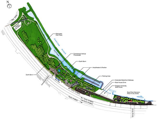
- A ramped promenade from the new bridge
at
Commercial Avenue will provide a scenic
vista of the Raritan River  and
a grand entranceway for pedestrians
into Boyd Park. Improvements also include
a new amphitheater adjacent to the park
pavilion and take in the area closest
to the outer roadway. and
a grand entranceway for pedestrians
into Boyd Park. Improvements also include
a new amphitheater adjacent to the park
pavilion and take in the area closest
to the outer roadway.
- Boyd Park will be extended into the
former City Docks
area and a new boat ramp and picnic
pavilion, along with ample parking for
the park will be provided.
- New sidewalks and lighting will be
provided throughout
areas that pedestrians and bicyclists
use.
- Noise walls will be constructed to
buffer several
residential locations.
- Aesthetics in the Route 18 reconstruction
area will be
enhanced by burying utilities underground,
extensive landscaping and architectural
and other urban design treatments. The
Albany Street tunnel and the Richmond
Street bridge will be constructed with
a sensitivity to their neighborhoods.
|